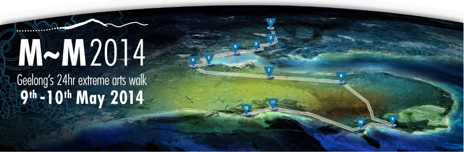
M~M2014 Timetable and Map
““M~M introduces a sense of neighbourhood across the vast regions of Greater Geelong…” ”
|
Station name and location details |
Distance to Next Station |
Walking Time* |
Station features and walking notes |
|
Friday 9th May 2014 |
||||
|
Station 1 |
Big Rock |
Station opens: 1:00pm |
2:30pm-3:30pm Gathering of the Elders Ceremony |
|
|
En route |
From: You Yangs |
12.7km |
2hr 30min |
Downhill into dusk. Follow the edge of the park to Flinders Avenue. Walk along the road past farmland into the sunset, through Serendip Wildlife Sanctuary, along grass reserves and Kevin Hoffman Walk. An informal grass path leads into suburban streets, and on to the Lara RSL. |
|
Station 2 |
Lara RSL Hall |
Station opens: 5:00pm |
Evening BBQ fundraiser at the historic RSL Hall. Walking Circle: Floating Candles and Weather Balloon |
|
| En route |
From: Lara RSL Hall |
6.3km |
1hr 15min |
Bring your lantern or torch along for the night walk along Hovells Creek through native plantings. Pass near the Hume and Hovell monument, through grasslands, then along the bike trail. |
|
Station 3 |
Limeburners Lagoon |
Station opens: 6:25pm |
Rotunda by the moonlit lagoon. Refreshments, Geelong Grammar, wetlands, bird life, saltbush revegetation. |
|
| En route |
From: Limeburners Lagoon |
4.8km |
55min |
Walk along the Western Bay Walk with the big ships, and see the dramatic lights of the industrial heartland against the backdrop of the City. |
|
Station 4 |
Moorpanyal Park |
Station opens: 7:30pm |
Peaceful bay view, refreshments. |
|
| En route |
From: Moorpanyal Park |
6.7km |
1hr 25min |
Continue the Western Bay Walk, and Bob McGovan Path all the way to the City Waterfront, twinkling lights, boats and piers. |
|
Station 5 |
Steampacket Gardens |
Station opens: 7:00pm |
Night lights across the bay, bars, restaurants and cafés, historic Carousel, public art, skate park, Poppykettle Playground, Cunningham Pier. Be sure to book accommodation. |
|
Saturday 10th May 2014 |
||||
|
Station 5 |
Steampacket Gardens |
Station opens: 5:30am |
Take in the Bay view and Cunningham Pier at dawn, and see the city wake up as the sun rises. | |
| En route |
From: Steampacket Gardens |
2.9km |
30min |
Walk from the Bay to the Barwon River in just half an hour past Kardinia Park, home of the Geelong Cats, to breakfast on the river. |
|
Station 6 |
Barwon River Rowing Precinct |
Station opens: 6:00am |
Delicious breakfast on sale, edible stage, kids activities, Barwon River views. |
|
| En route |
From: Barwon River Rowing Precinct |
10.6km |
2hr 30min |
Walk along the river, then by footpath through older residential areas of South and East Geelong, then onto the Bellarine Rail Trail. Remnant and indigenous vegetation, wildlife, safe and tranquil environment. One of the longest sections. |
|
Station 7 |
Christies Road Leopold |
Station opens: 8:30am |
BBQ fundraiser by the Bellarine Rail Trail, music and song. |
|
| En route |
From: Christies Road Leopold |
7.6km |
1hr 33min |
Continue along the Bellarine Rail Trail. Rare grasses, rolling hills, vineyards and You Yangs views. |
|
Station 8 |
Drysdale Station |
Station opens: 10:00am |
Historic Drysdale Station will be open to the public. Abundant produce from Geelong’s farming community on sale – olive oil, wine, vegetables, berries etc. Lake Lorne, music and song. |
|
| En route |
From: Drysdale Station |
13.9km |
2hr 46min |
Continue along the Rail Trail to Queenscliff through the farming heartland of the Bellarine. Claim kudos for conquering the longest section of the contemporary songline. |
|
Station 9 |
Swan Bay Marine and Freshwater Discovery Centre |
Station opens: 1:00pm |
Welcome to the Borough of Queenscliffe, after your walk along Swan Bay an international RAMSAR site. Marine and Freshwater Discovery Centre open to explore. |
|
| En route |
From: Swan Bay Marine & Freshwater Discovery Centre |
2.8km |
33min |
Walk the promenade with stunning coastal views of The Heads, accompanied by sounds of wildlife. |
|
Station 10 |
Point Lonsdale Village |
Station opens: 2:00pm |
Cafes and stunning bay vistas. |
|
| En route |
From: Point Lonsdale Village |
8.5km |
1hr 40min |
Through Moonah groves and on past the lighthouse and Marine National Park. Be invigorated by the rolling surf of Bass Strait. The rare Hooded Plover breeds in this area. |
|
Station 11 |
Ocean Grove Surf Life Saving Club Reserve |
Station opens: 4:00pm |
Café, magnificent surf beach. Plastic bag artwork. |
|
| En route |
From: Ocean Grove Surf Life Saving Club |
3km |
26min |
The final stage is a gentle walk on sand and then a twisting pathway to the iconic walking bridge at the Barwon River mouth. Bring your lantern or torch to light the way. |
|
Station 12 |
Barwon Heads Foreshore |
Station opens: 4:00pm |
Welcome to Barwon Heads – a delightful fishing village with cafes and restaurants. The end of the journey followed by the Fire on Water ceremony. Food and drink stalls at the Walking Circle. Light your lantern for the final ceremony. Good idea to book ahead for dinner afterwards. Why not stay the night? 6:00pm-7:00pm Fire on Water Ceremony |
|
* GENERAL DISCLAIMER
The M~M2014 Basic Trail Map is intended as a general guide to the event journey. Although the content has been researched and prepared with due care, the City of Greater Geelong accepts no responsibility for errors or omissions that accidentally occur within this map, or injuries that may occur on the route. Times listed are approximate and may be subject to changes due to weather or other factors beyond our control on the day.
